
AFRICA NEWS
Your weather update: Heavy snow, rain and warning of fire for Tuesday

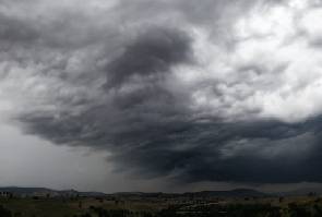
As an intense cold front looms, the SA Weather Service (SAWS) expects snowfall and rain over parts of the Western Cape for Tuesday.
Warnings:
Extremely high fire danger conditions are expected over western halves of the Free State and North West, Eastern Cape as well as the eastern half of the Northern Cape and extreme eastern parts of the Western Cape.
Heavy rain leading to localised flooding is expected over the Cape Winelands, western parts of the Overberg District and Cape Metropole of the Western Cape.
Gale force winds of 65 km/h are expected along the coast between Kleinzee and Plettenberg Bay from the morning, as well as over the north western parts of the Eastern Cape, north eastern parts of the Western Cape and the western interior of the Northern Cape.
Watches:
Disruptive snowfalls are expected over the Namakwa southern high ground and western high ground of the Western Cape from the evening.
High seas with wave heights of 6-7m are expected along the coastal regions between Cape Columbine and Cape Agulhas from the evening.
Special advisory:
An intense cold front is expected over the Western and Northern Cape provinces spreading to the Eastern Cape and Free State on Tuesday night into Wednesday.
“Small stock farmers are advised that a combination of rain, windy conditions and very cold temperatures are expected.”
The weather in your region
Gauteng will be fine and cool. The expected UVB sunburn index will be low.
It will be fine and cool to warm in Mpumalanga, Limpopo and the North West province.
The Free State will be warm in the west, otherwise fine and cool. It will be windy in the western parts.
The Northern Cape will be fine, windy and cool to warm in the north western parts. Otherwise it will be cloudy and cold, but very cold over the southern high ground, with rain from the morning and snow over the southern interior in the evening. Strong to gale force winds are expected over the western interior. The wind along the coast will be strong north-westerly to westerly, becoming moderate to fresh late evening.
It is expected to be cool over the eastern interior and along the south coast of the Western Cape. Otherwise, it will be cloudy, cold, and very windy with rain in the west from morning, spreading to the rest of the province throughout the day. Showers in the evening, while snowfalls are expected over the western mountains. The wind along the coast will be strong to gale force north-westerly to westerly, but fresh along the south coast at first.
The Eastern Cape will be fine and warm, with near-gale to gale force winds over the interior. It will become cloudy from the afternoon, with evening showers. The wind along the coast will be moderate north westerly becoming strong westerly in the afternoon.
Fine and warm but cool in the west of Durban. The wind along the coast will be fresh to strong north-easterly north of Richard’s Bay, otherwise moderate to fresh. The expected UVB sunburn index will be high.

NEWS24


Inflation slows down marginally from 25.8% to 25% in April

T-bill yields to fall – Databank Research

Cocoa price falls 30% over market liquidity fears

HOT VIDEO: Leaked Video of a Ghanaian Seamstress goes viral

Road Safety Authority narrates how buttocks causes road accident
VIDEO: Pupil teacher c*ught having s*x with 11-year-old in an uncompleted Building
-
 Lifestyle1 month ago
Road Safety Authority narrates how buttocks causes road accident
-

 GENERAL NEWS2 months ago
Why 15 police officers stormed Owusu Bempah’s church – Kumchacha narrates
-

 GENERAL NEWS1 month ago
Watch how Ibrahim Mahama rode Honda superbike to pay last respects to late friend
-

 GENERAL NEWS2 months ago
How Offinso residents storm destooled queen mother’s house, demand for new chief
-

 South Africa News2 months ago
Woman thrown out of a speeding taxi while on her way to work
-
 GENERAL NEWS4 weeks ago
Deadly clash between youth and navy personnel results in two deaths at Tema Manhean
-

 SHOWBIZ KONKONSAH4 weeks ago
Junior Pope’s Death: Video of John Dumelo refusing to join canoe for movie shoot over safety concerns resurfaces
-

 News Africa2 months ago
‘Satanically dubious’ – SCOAN releases statement on BBC’s report about TB Joshua, church