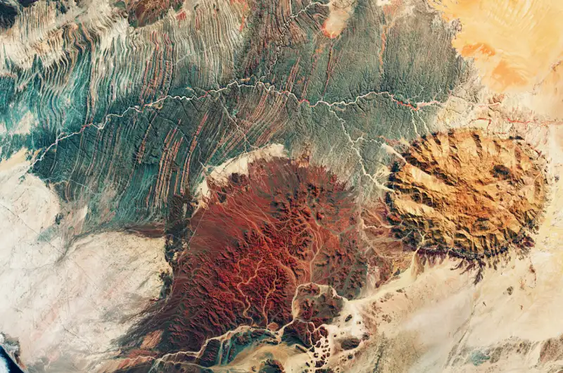
The area pictured here includes part of the Kunene and Erongo regions, two of Namibia’s 13 regions. The Ugab River, visible as a winding, white line cutting through the center of the image, clearly marks the border between Kunene (to the north) and Erongo.
This false-color image was taken in April 2024 and Copernicus Sentinel-2’s near-infrared channel was used to highlight the sparse vegetation of this extremely arid, desert landscape. Red patches of vegetation are discernible along the Ugab’s main course.
The Ugab is ephemeral, only flowing above the surface of its sandy bed a few days each year. However, its subterranean water serves as an important resource for diverse wildlife, including the rare desert elephant.
Namibia is renowned not only for its spectacular landscape, but also for offering clues to the history of tectonic plate movement in this part of Africa.
Several significant geological features dominate this image.
The circular, light brown formation on the right stands out from the surrounding plane; it is the Brandberg Massif, a granite mountain and, reaching 2500 m, one of the highest points in Namibia. It originated during the Early Cretaceous rifting that led to the opening of the South Atlantic Ocean.
In the Ugab River valley, the impressive outcrop visible in shades of blue is the Zerrissene turbidite system, comprising folded, sedimentary rocks and spanning nearly 2,700 sq km.
The ring-shaped rim of the Messum Crater can be seen in the bottom center of the image. Contrary to its appearance, the crater was not formed by a meteorite or asteroid impact, rather it’s part of a collapsed volcano. With a diameter of more than 20 km, it consists of two concentric circles of hills surrounding a wide, flat basin.
Human presence in the area is minimal. Straight, white lines cutting across the landscape are roads, a subtle reminder that this region is not entirely unpopulated.