
The United Nations General Assembly has endorsed a new world map that gives a more accurate visual representation of the size of Africa and other continents.
The resolution, spearheaded by Togo and supported by African Union member states, promotes the use of the Equal Earth projection as an alternative to the widely used Mercator projection.
The proposal was overwhelmingly supported, with 164 countries voting in favour. The United States was the only country to vote against it, while six countries abstained.
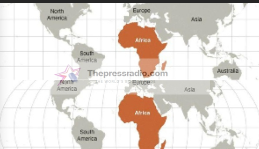
The change has attracted significant attention because Africa appears considerably larger on the Equal Earth map than it does on the traditional Mercator projection.
The Mercator projection was developed by Flemish cartographer Gerardus Mercator in 1569, primarily for maritime navigation. While it is useful for navigation because it preserves angles and directions, it significantly distorts the relative sizes of land masses, particularly as they move farther from the Equator.
One of the most striking examples is the comparison between Africa and Greenland. On a traditional Mercator map, Greenland can appear roughly comparable in size to Africa. In reality, Africa is about 14 times larger than Greenland.
Under the Equal Earth projection, Africa occupies a much larger area on the map, while regions such as North America and Europe appear smaller relative to their actual surface areas. Australia, South America and parts of Asia also receive a different visual representation.
The Equal Earth projection was developed in 2018 by cartographers seeking to preserve the relative surface areas of continents while maintaining recognizable shapes. However, like every flat map of a spherical planet, it still involves some compromises and does not eliminate every form of geographical distortion.
The United Nations resolution does not legally ban the Mercator projection or immediately force every country to replace its existing maps. Instead, it encourages governments, educational institutions and other organisations to consider projections that provide a more accurate representation of continental sizes.
Togo has played a leading role in promoting the change. Foreign Minister Robert Dussey argued that maps influence education and how people perceive the world, making accurate representation important.
The initiative has also been described as part of broader African efforts to challenge historical representations that have often made the continent appear smaller and less significant than its actual geographical size.
The debate has generated reactions across the world, with supporters welcoming the change as a correction of a longstanding geographical distortion. Critics, meanwhile, have questioned whether changing a map projection should be a major international priority.
Regardless of the debate, the UN’s decision has brought renewed global attention to the way maps shape people’s understanding of the world.
Source: Thepressradio.com